
BlueChart® 2010.5
To view your BlueChart g2 and g2 Vision regions please use the
BlueChart® g2
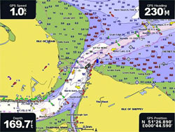 BlueChart® g2 mapping features smooth layering and seamless integration of map graphics for easy panning, scrolling and zooming. With rich colours and shading for easy interpretation and clear visibility, this marine charting offers comprehensive IALA navaid symbology and marine services. A choice of 3D ‘Mariner’s View’ map perspective, or the familiar 2D direct overhead view makes chart reading and orientation easier.
BlueChart is styled to match the appearance of paper charts when displayed on a Garmin chartplotter or GPS mapping handheld device.
Features include shading between depth contours, spot soundings, navaids, port plans, wrecks, obstructions, intertidal zones, fishing charts, restricted areas and more. BlueChart cartography is object-oriented, which means you can pan to an object on the map and instantly view information about that point. Additionally, Fishing Charts contain detailed bathymetric data to emphasise bottom contours and depth soundings. These charts also remove navigation information from the map to reduce clutter and give clearer definition to the sea floor, ideal for fishing.
NEW for Version 2010.5, improved density of spot soundings, additional display of 20m, 50m, 100m, 500m and 1000m depth contours to ‘Nautical Chart’ view, as well as numerous chart and notice to mariner updates.
Get charts now
BlueChart® g2 Vision®
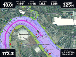 Enhance your nautical navigation with BlueChart g2 Vision high-precision charting. Garmin’s most detailed digital marine data contains premium mapping features including high-resolution satellite imagery, 3D perspectives above and below the waterline, AutoGuidance technology, aerial photography of ports, harbours, marinas and waterways and coastal roads with points of interest. BlueChart g2 Vision gives mariners greater capabilities on the water, with useful navigation landmarks and marine landscape detail to boost your chartplotting technology.
- AutoGuidance technology finds the best course for navigation
- High-resolution satellite imagery
- Aerial reference photography for “real world” views of ports, harbours, marinas, etc
- Mariner’s Eye View provides 3D perspective of chart information above the waterline for a quick, reliable and easy position fix
- FishEye View gives 3D perspective below the waterline, displaying bottom contours based on bathymetric charting data
- Tidal graphs, current arrows, marine services, coastal roads and points of interest detail
- Land-based information including detailed coastal roads up to five miles inland (non-routable) and business points of interest
Get charts now
Preloaded Plotter Updates
If you have a preloaded plotter (GPSMAP 450 series, 550 series, 750 series devices) please click here to purchase your BlueChart g2 � Preloaded Update Cards for UK & IRE.
For those customers who were affected by the version 2009 BlueChart recall, or have purchased BlueChart g2 Vision 2008.5 charting since June 2009, please contact Garmin customer services on 0808 238 0000 or email [email protected].

