
cityXplorer™ Maps
Extend the usage of your sat-nav beyond your car, with cityXplorer™ maps providing navigation on foot and on public transport.
If you’re visiting a new city on holiday or business, cityXplorer helps you get around, travelling just like a local. The enhanced pedestrian mode gives you directions for walking including footpaths and shortcuts through parks – places you wouldn’t be accessing while in your car. It also tells you where to catch trains, buses and tubes (dependent on the city), and how long it will take to reach your destination. cityXplorer even has public transport timetables to ensure you arrive at the station on time and help avoid long waits (dependent on the city).
Mapping for cities not on your sat-nav: cityXplorer can also be used to enhance a regional Garmin nüvi sat-nav. For example, you may be planning a city break to New York but only have mapping for Europe. Simply upload cityXplorer and you’ll get street mapping for that city, and be able to get turn-by-turn directions to where you want to go.
Tourist Guides: Add an AA Guide for London, Paris, Rome or New York to find out about attractions and read about their history, opening times and costs. With tips on places to eat, stay and shop it’s your true pocket sized tour guide!
cityXplorer is available as a convenient download that can be installed directly onto your Garmin nüvi sat-nav. And with prices from only £7.49 per download, you’ll have money left over to spend in the big city.
cityXplorer™ Maps — European Cities
Navigate the big city with cityXplorer™ with detailed street mapping and points of interest such as restaurants and places to visit. The enhanced pedestrian navigation¹ gives you street directions that let you walk to your destination or use public transport to get you where you need to go.
|
Available European
Cities |
Navigation Already
Covered |
Timetables Available
From |
|
Underground
Tram Bus Commuter |
|
|
|
Tram
Bus |
|
|
|
Underground
Tram Commuter |
|
|
|
Underground
Tram Commuter |
||
|
Underground
Tram Bus Commuter |
-
- Q2 2010 - |
|
|
Underground
Tram Bus Commuter |
|
|
|
Tram
|
|
|
|
Underground
Tram Bus |
||
|
Underground
Tram Commuter |
||
|
Bus
Commuter |
||
|
|
|
|
|
Tram
Bus Commuter |
Q2 2010
- - |
|
|
Bus
|
Q2 2010
|
|
|
Bus
Tram |
||
|
Underground
Tram |
||
|
Tram
Bus Commuter |
||
|
Underground
Commuter |
||
|
Underground
Tram Bus Commuter |
Q2 2010
Q2 2010 Q2 2010 - |
|
|
Metro
Tram Commuter |
|
|
|
Tram
|
Q2 2010
|
|
|
Underground
Tram |
||
|
Underground Tram Commuter |
||
|
Bus
|
Q2 2010
|
|
|
Underground
Tram Commuter |
||
|
Underground
Tram |
||
|
Underground
Tram Bus |
||
|
Underground
Tram Bus Commuter |
|
|
|
Underground
Tram Bus Commuter |
||
|
Underground
Tram |
||
|
Tram
|
Q2 2010
|
|
|
Underground
Tram Commuter |
||
|
Underground
Tram Bus |
||
|
Tram
Bus Rail |
||
|
Underground
Tram Bus Commuter |
||
|
Tram
|
|
|
|
Commuter
|
|
|
|
Underground
Tram Bus Commuter |
||
|
Bus
|
|
|
|
Underground
Tram |
||
|
Tram
Bus Commuter |
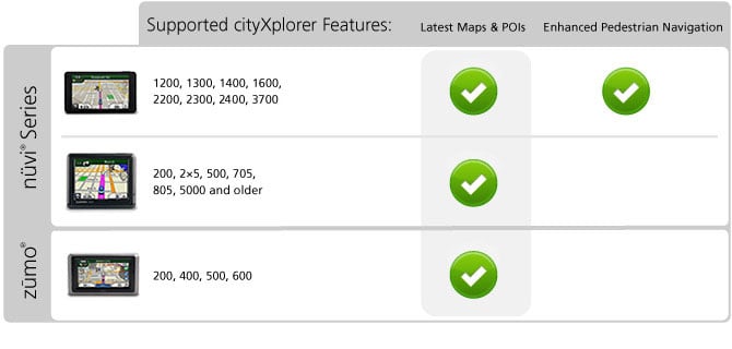
¹Enhanced pedestrian mode, which includes public transport information, is available on compatible devices only:
cityXplorer™ Maps — North American Cities
Navigate the big city like your hometown with cityXplorer. Detailed city maps provide the latest roads and points of interest for the metropolitan area, plus enhanced pedestrian navigation — street directions that let you use public transportation to get you where you need to go.
cityXplorer™ Maps — Rest of the World Cities
Navigate the big city with cityXplorer™ with detailed street mapping and points of interest such as restaurants and places to visit. The enhanced pedestrian navigation¹ gives you street directions that let you walk to your destination or use public transport to get you where you need to go.