BaseCamp™
Free Download: Download for PC | Download for Mac
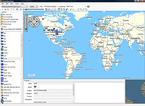 Take charge of your next adventure with our free BaseCamp software. With BaseCamp you can view and organise your maps, waypoints, routes and tracks and send them straight to your Garmin device ready to go.
Survey the Terrain
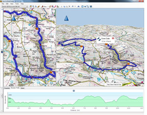
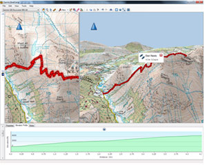 BaseCamp displays your topographic map data in 2D or 3D on your computer screen complete with elevation profiles. Then you can view and rotate the maps from any angle.
For the highest level of topographic detail available, check out Garmin GB Discoverer� for your outdoor handheld. GB Discoverer data is comparable to 1:25,000-scale Ordnance Survey Explorer and 1:50,000 scale OS Landranger maps, with the familiar symbols, contours, elevations, summits, paths, routable roads and more. GB Discoverer is available as a single card/download for 1:50k coverage of all of Great Britain or individual 1:25k scale maps for your favourite National Park or Trail. BaseCamp will automatically read your GB Discoverer map data when your Garmin is connected to your computer via USB, ready for you to plan your next adventure.
Plan Your Route
 Prepare for your trip by creating waypoints and routes on your computer and then upload them to your device.
Estimate the difficulty of your hike before you start using BaseCamp�s �Track Draw� feature to trace your intended path. Instantly view the elevation changes over your entire route with detailed mapping such as Garmin GB Discoverer, Garmin Eire Discoverer and our other European Topographical titles. When your trip is done, BaseCamp shows an animated playback of your routes and tracks over time, so you can see where you�ve been.
Geotag Photos
BaseCamp lets you geotag photos � add a photo to any waypoint on the map � so you know exactly what the scenery is like at any given location. You can even transfer these photos to and from your compatible Garmin device as motivation to inspire you to reach your destination!
Transfer Satellite Images
With BaseCamp and a BirdsEye™ Satellite Imagery subscription, you can transfer an unlimited number of satellite images to your Garmin device and seamlessly integrate those images into your handheld's maps for a true representation of your surroundings.
Features
- View 1:25K or 1:50K Ordnance Survey maps*
- Displays maps in 2D or 3D*, including elevation profiles
- Rotate and view maps at any angle
- Create waypoints and routes on your computer and transfer maps, waypoints, routes, tracks and geotagged photos between your computer and device
- Transfers satellite images to your device (with optional BirdsEye™ Satellite Imagery subscription)
- Shows animated playback of your travelled routes and tracks over time
- Supports geotagged photos
- Easily organise data into folders
- Exports user data for viewing in Google Earth™
- Includes advanced geocaching support; able to import data from geocaching.com
* Maps not included
Installing BaseCamp™
Download from garmin.com
- Choose BaseCamp for PC or BaseCamp for Mac.
- Click Download and save the file to your computer.
- Locate the saved file on your computer and open it.
- Follow the onscreen instructions to finish installing BaseCamp.
System Requirements
- BaseCamp requires an IBM-compatible PC running Windows® XP Service Pack 2 or later operating system or any Intel-based or PowerPC G4 or later Mac OS*.
- Microsoft®.NET framework 2.0 SP1 is required. A current version of .NET will be installed if needed.
- A video card that supports OpenGL version 1.3 or later is needed to view 3-D terrain.
- If you experience problems when interacting with the map views, please make sure that you have installed current video card drivers.
* PowerPC G4 or later Mac OS users must download the legacy version of BaseCamp™ version 2.x
Change History for PC
Changes made from version 3.0.6 to 3.1.1:
- Added support for multiple new BirdsEye products.
- Added support for sorting, searching, browsing and filtering user data.
- Added support for ejecting devices from within BaseCamp.
- Added support for filtering tracks.
- Added support for display of track statistics and temperature.
- Added support for time offsets while geotagging photos from tracks.
- Added support for editing multiple waypoints, routes and tracks at a time.
- Added support for importing geotagged photos.
- Added support for full screen mode.
- Added support for non-rectangular selection area for BirdsEye downloads.
- Improved performance while importing, geotagging, autosaving and routing.
- Improved support for various DPI settings.
- Reduced memory required by BirdsEye imagery.
Changes made from version 3.0.5 to 3.0.6:
- Added support for the GB Discoverer series of products.
- Added support for the City Navigator Israel series of products.
- Improved memory usage when drawing maps.
- Improved auto routing calculation speed.
- Improved address searching when searching near 'center of map'.
- Improved indexing of map products installed on devices or SD cards.
- Changed error reporting for imported files.
- Fixed issue when rendering the '&' sign on map labels.
- Fixed startup issue related to diacritics or the German Eszett in the database.
- Fixed startup issues related to bad 3d settings.
- Fixed errors that could occur when changing filtered route settings in the middle of creating a route.
- Fixed errors when editing geotagged photos.
- Fixed input of custom grid values.
- Fixed issues that could happen when changing the map font.
- Fixed issues that would result in sections of the map missing when using an NT map product.
- Fixed issues when changing datum and grid.
Changes made from version 3.0.4 to 3.0.5:
- Added localization for the following languages: Chinese (Traditional), Croatian, Czech, Danish, Dutch, Finnish, French, German, Hungarian, Italian, Japanese, Norwegian (Bokmal), Polish, Russian, Slovak, Slovenian, Spanish, Swedish
- Added the ability to unlock BirdsEye Imagery for a specific device.
- Added support to recognize European Topographic cards as retail products.
- Improved map projection when printing BirdsEye Imagery.
- Change to preserve subfolders when writing Garmin Custom Maps.
- Change to correctly resolve relative paths in links on waypoints received from devices.
- Change to use a more reasonable zoom level when selecting 'Show on map' for a single find result or waypoint.
- Change to update the database to reflect missing images when doing a 'Restore' when the images were excluded from the backed up.
- Change to preserve selection of device when starting BirdsEye wizard, if a device was previously selected.
- Change to read maps on SD cards written to the \Map subfolder.
- Fixed auto-routing issues on certain maps.
- Fixed copy/paste of geotagged photos from a device not copying the photo.
- Fixed possible issues when launching an external file or URL link.
- Fixed issues when reading geotagged photos with invalid timestamps.
- Fixed displaying postal code twice in POI property balloons in some European maps.
- Fixed issues geotagging photos with Asian language paths.
Changes made from version 3.0.3 to 3.0.4:
- Fixed startup issue when migrating Garmin BirdsEye imagery from earlier versions of BaseCamp into version 3.0.3.
Changes made from version 3.0.2 to 3.0.3:
- Added display of which devices a BirdsEye Imagery is unlocked for.
- Added the ability to control which map feature lines are shown.
- Improved memory usage for Garmin BirdsEye Imagery and Garmin Custom Maps.
- Improved user feedback while transferring to folders and devices.
- Improved reported information when Garmin Custom Maps cannot be imported.
- Changed to allow transfer of partially downloaded BirdsEye Imagery.
- Added ability for BaseCamp to attempt reading all Garmin map images (.img files), regardless of name, from removable media.
- Fixed issue when using Find with a map that does not have a city table.
Changes made from version 3.0.1 to 3.0.2:
- Eliminated error messages at startup with blank SD cards.
- Fixed several printing related issues.
- Fixed issue when hovering over the 3D view after turning off lines or areas.
- Fixed issue when importing a KML file that didn't contain any visible ground overlays.
- Fixed issue with track and route join.
- Fixed issue with track and route insert.
- Fixed issue with geotagged photos on devices not being read.
Changes made from version 2.0.9 to 3.0.1:
- Added download, display, and transfer of BirdsEye satellite imagery to supported devices.
- Added download, display and transfer of Garmin Custom Maps to supported devices.
- Added the ability to use BaseCamp with the pre-installed maps on a connected device or pre-programmed SD card.
- Added poster printing.
- Added printing of USGS Quads and other public land survey areas.
- Added tools for auto-routes.
- The full information set for Geocaches is now correctly transferred to the device.
- Improved handling of back-up database.
- Improved the drawing speed of certain European maps.
- Improved the reading speed and display of Geotagged photos.
- Improved stability while running on Windows 7.
- Numerous refinements and problem fixes.
Changes made from version 2.0.8 to 2.0.9:
- Fixed issue with BaseCamp sending waypoints, routes and tracks to a location on the device that the device doesn't read.
Changes made from version 2.0.7 to 2.0.8:
- Added localization for the Traditional Chinese and Japanese languages.
- Added 2D display of products that don't contain elevation data.
- Improved zooming with mouse scroll wheel.
- Corrected issues detecting removable drives.
- Corrected issues Geo-Tagging photos.
- Corrected issue with the Recenter Map screen marker not displaying correctly in the 3D view.
- Corrected issue with printing around the Anti-Meridian at low zoom level.
- Importing GPX files now preserves track notes.
- Improved rendering performance of selected map products.
Changes made from version 2.0.6 to 2.0.7:
- Enlarged the 3D playback arrow.
- Corrected the mouse scroll wheel behavior on the Cache Log.
- Addressed various printer related problems.
- Now showing more information relating to printer and print driver problems.
- Corrected various problems encountered while launching BaseCamp.
- Corrected some toolbar layout issues.
- Corrected some problems that were occurring during transfer to an external device.
- Fixed a problem which was occurring under certain conditions when deleting items from a folder.
- POI searching is now working for Topo Morocco.
- Driving speed on routes now works correctly.
Changes made from version 2.0.5 to 2.0.6:
- Added a worldwide base map for use with BaseCamp.
- Automatically named routes will now be named correctly when created in a folder.
- Improvements to undo and redo functionality.
- Better handling of tracks that only contain 1 point.
- Find now works if the location is set to 'Center of Screen'.
- Improved print preview functionality on smaller screens.
- Grid lines print correctly.
Changes made from version 2.0.4 to 2.0.5:
- Error reporting improvements to gather additional information when BaseCamp crashes.
- User settings are preserved after a version upgrade.
- Updated magnetic variation data.
- Geotagged images will be shown in the correct orientation and drawn faster.
- Skip printing blank pages for routes without an elevation profile or notes.
- The list of user waypoints shows the symbol or image shown on the map.
- Improved searching for addresses outside of the United States.
- Added additional scroll wheel support.
- Fixed errors when opening non-English help.
- Preserve the pitch angle of the 3D map.
Installation Instructions
- Download the Garmin BaseCamp update file into a directory on your hard drive. (i.e., c:\downloads).
- Change to the directory in which you downloaded the files, (i.e., c:\downloads), and run the executable file (.exe). Follow the onscreen instructions to complete the update of your BaseCamp installation.
System requirements
- IBM-compatible PC running Windows XP Service Pack 3 or later operating system.
Change History for Mac
Changes made from version 3.0.2 to 3.1.1:
- Added support for additional BirdsEye products.
- Added ability to select non-rectangular area for BirdsEye download.
- Added ability to search through all text in user data for specified string.
- Consolidated POI, address and new user data search.
- Enhanced display of find results on the map.
- Added support for custom waypoint symbols, including ability to send and receive symbols to non-mass storage devices like the GPSMap 60 series.
- Added support for address search on maps read from a device.
- Made a significant improvement in memory efficiency for BirdsEye images.
- Added ability to search for and download Garmin Connect activities. Use Find Garmin Connect Activities under the Find menu.
- Added ability to transfer tracks to Garmin Connect.
- Added support for a new plug-in architecture that allows users to added new import and export formats. Go to the Mac BaseCamp area of http://forums.garmin.com for more information.
- Added ability to import TCX files.
- Added ability to export TCX, CSV and tabbed text files.
- Fixed numerous issues reported from the field.
Changes made from version 3.0.1 to 3.0.2:
- Translated BaseCamp into 18 languages: Chinese (Traditional), Croatian, Czech, Danish, Dutch, Finnish, French, German, Hungarian, Italian, Japanese, Norwegian (Bokmal), Polish, Russian, Slovak, Slovenian, Spanish, Swedish
- Significantly reduced the memory consumption of BaseCamp due to BirdsEye Imagery.
- Eliminated the redundant sending of routes and tracks to non Mass Storage devices such as eTrex and 60CSx.
- Reduced the transfer time of BirdsEye Imagery to a device.
- Added a summary of ascent and descent to tracks and measurements.
- Fixed issues with drawing the map.
- Fixed issues related to loading Garmin Custom Maps.
- Fixed an issue where BaseCamp could crash while renaming waypoints in a route.
- Fixed a crash caused by loading bad Open Street Maps. BaseCamp will not load these bad maps.
- Fixed many reported issues.
Changes made from version 2.0.1 to 3.0.1:
- Added download, display, and transfer of BirdsEye satellite imagery. This requires that you have a supported Garmin GPS. See here for more information.
- Added download, display and transfer Garmin Custom Maps to supported devices.
- Added the ability to use pre-installed maps on a connected device or pre-programmed SD card.
- Added ability for BaseCamp to display any Garmin map. Maps do not need to have Digital Elevation Model (DEM) data to be displayed in BaseCamp now.
- Added support for the data sync capability in the Oregon 450 and 550 and Dakota 10 and 20.
- Added ability to drag and drop user data to and from connected devices.
- Added ability to edit multiple waypoints.
- Fixed issue with garbage characters that were displayed in pop‐up labels in Snow Leopard (10.6).
- Added printing of USGS Quads and other public land survey areas.
- Added ability to reset preferences to factory defaults.
- The full information for geocaches is now visible when transferred to devices that have enhanced support for geocaching, including hints, terrain, difficulty and logs.
- Improved handling of back-up database.
- Improved the drawing speed of certain European maps.
- Improved the reading speed and display of Geotagged photos.
- Adjust map drawing colors to better distinguish between major highways and interstates.
- Added support for touchpad multi-touch gestures.
- Added to print on several pages.
- Fixed issue where information about found POI or address was not displayed correctly in Snow Leopard.
- Fixed an issue where selecting a waypoint symbol in the Waypoint Dialog could cause a crash.
- Numerous refinements and problem fixes.
- Added numerous other refinements and problem fixes.

